Saxon Charters of 943 and 968
A Whiteparish local history page from younsmere-frustfield.org.uk
Two Saxon Charters refer to Whiteparish, the first from 943 and the second 968 and both refer to the same three hides of land in Frustfield. In the first King Eadmund granted three hides of land to his thegn Wulfgar, and in the second the same land is granted to Wilton Abbey [confirm]. Matcham (page 67) in 1844 reproduced the description of the bounds for the 943 charter in Anglo-Saxon with an English translation and for the 968 charter in Anglo-Saxon with a Latin translation.
Matcham also made a connection between the charters and the Earldoms, an area of land that separated the main and detached parts of Whiteparish at the time of the 1842 Tithe Map. At the dissolution of the monasteries in 1542 and 1544 William Herbert, the first Earl of Pembroke, and his wife were granted the estates belonging to the dissolved abbey of Wilton by King Henry VIII. This land included the Earldoms and the charters were among the documents owned by the abbey, presumably to prove title. Against this background it seems very strange now that Christopher Taylor (see below) should have embarked on his study of the charters and concluded that they represented not the Earldoms, but Titchborne Farm, the Newhouse estate and a substantial area now in the adjoining parishes of Alderbury and Downton. The combination of Titchborne and Newhouse is logical, as Newhouse was created out of Titchborne manor land, but the addition of land on the other side of the present parish boundary is very odd as it would imply that the mutual boundaries of Whiteparish, Alderbury and Downton had changed since these Saxon times. It would be challenging to explain how the abbey had come not to own Titchborne at the dissolution, but to own the Earldoms instead, while at the same time the boundaries of its original property had come to change so radically.
For the sake of completeness in analysing the documentary evidence covering Whiteparish, the rest of this page details and analyses Christopher Taylor's conclusions as recorded and published in the Wessex Archaeology Magazine in 1964. Personally I believe that he was mistaken and may have been unaware of the origin of the charters and the ownership by the abbey of the Earldoms. He only lived in Whiteparish for a few years [specify] and is known for his somewhat uncritical and speculative proposals in the other papers he produced while in Whiteparish [link to references].
I do not agree with the conclusions drawn by Christopher Taylor below (see above). I accept the more widely held view from both before this paper and in later publications that the land in Frustfield granted by these Saxon Charters is The Earldoms, given to Wilton Abbey in 968 and taken by Henry VIII at the dissolution of the monasteries and granted to the Earl of Pembroke. As an example, Matcham provides the text of the charters and is clear that they describe The Earldoms - his text is shown below.
Christopher Taylor in 1964 made a detailed analysis of the boundaries described in these documents by working back from later documents that helped pinpoint the land in question, with his map shown below. As interpreted by Taylor the bounds surrounded the 1842 Tithe map area of Titchborne Farm (Abbotstone) with the addition of four pieces of land:
- Privett Wood (now Cheyney's Wood) in Downton Parish
- Newhouse Park - just the part of the park that lies in Whiteparish, not the Downton part
- Land on Pepperbox Hill west of the A36
- 54 acres in Downton Parish called Black Down
The maps below show Taylor's map from WAM Vol 59, 1964, p 115 on the left, and the same details overlaid on the 1842 Tithe Map on the right, showing Abbotstone Manor in purple. The 1842 parish and Abbotstone Manor boundary can be seen running directly between points (1) and (5), with land to the left (west) of this the four extra areas listed above, these now being in Downton Parish. The mauve area to its right is Moore Manor and the green area above is the edge of Whelpley Manor.
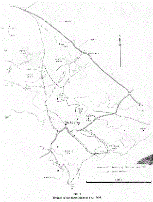
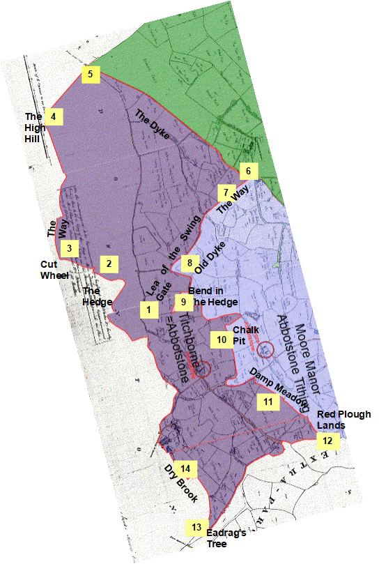
Left: The map from Taylor's article giving his interpretation of the boundary. Right: the boundary superimposed on the 1842 Tithe Map
See 1842 manors and tithings for the detailed Tithe Map used for the underlay of this view (scroll to the bottom of the map).
For a larger image of Taylor's map see here, copyright Christopher Taylor [poor quality - rescan]
[The overlaid map is at Taylor references/Frustfield 3 hides boundary Taylor.odg]
Christopher Taylor claims that these charters and his analysis provide us with the extent of Abbotstone Manor in Saxon times. As the charters describe the land as being in Frustfield it would be necessary for the Whiteparish parish boundary to have shifted since that time, the area in question being the area of Downton parish outside the Tithe Map extent bearing the labels 2, 3, 4 and 5 on the map above.
Saxon Charters
| Saxon Charter 943 |
The land that became Abbotstone Manor and later Titchborne was first referred to in a charter in 943 in which King Eadmund granted three hides of land to his thegn Wulfgar. |
| Saxon Charter 968 |
Abbotstone/Titchborne Farm [Taylor] 80 cartloads of wood from Melchet Forest under South Newton clearly refer to this land. Granted to Wilton Abbey in 968. |
The text of each of these charters is reproduced below, firstly from Matcham and secondly from esawyer.org.uk.
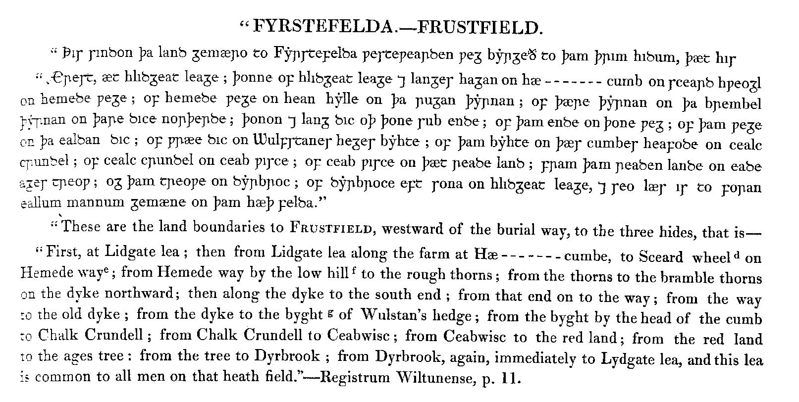
The boundaries of Abbotstone as described in the charter of 943 [Matcham page 67]
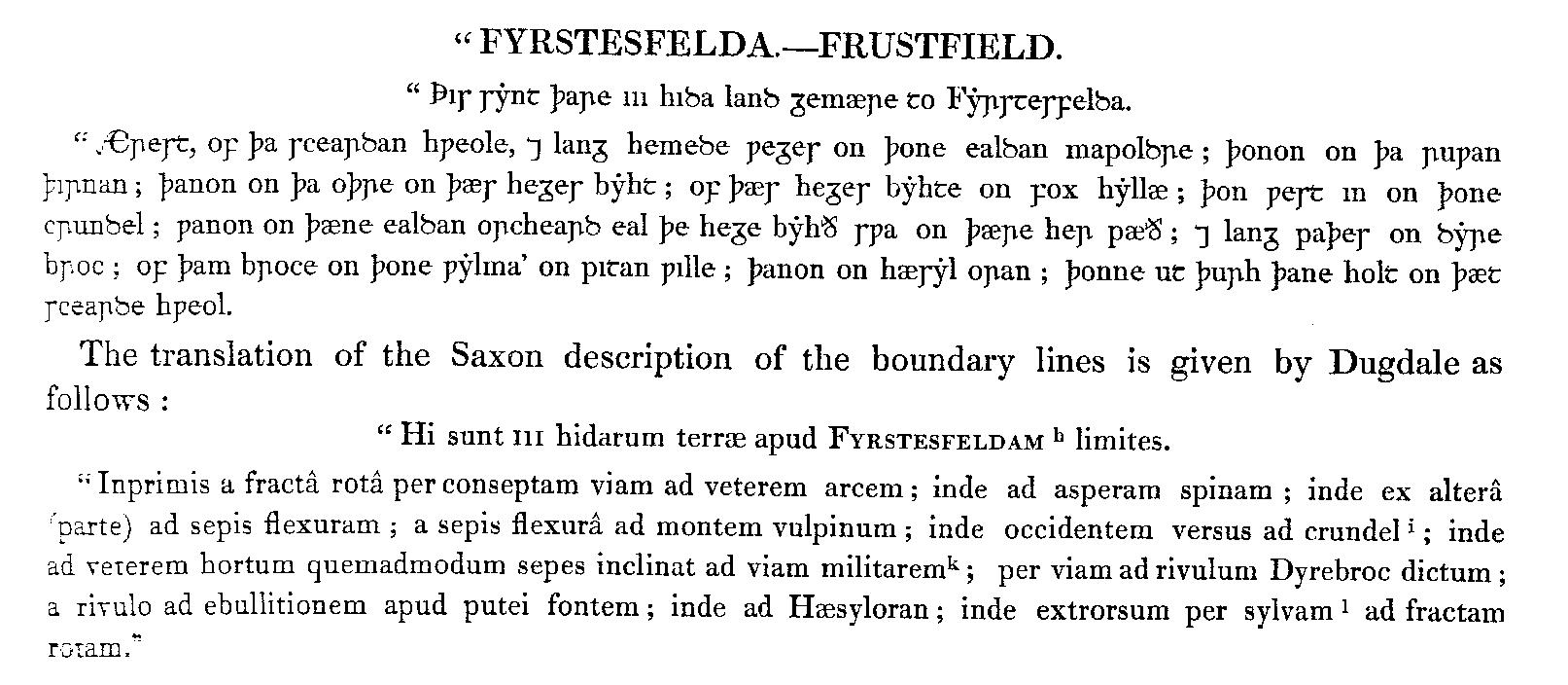
The boundaries of Abbotstone as described in the charter of 968 [Matcham page 67]
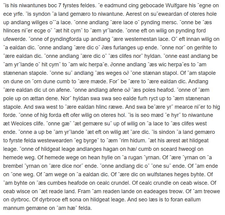
The boundaries of Abbotstone as described in the charter of 943 [esawyer.org.uk]
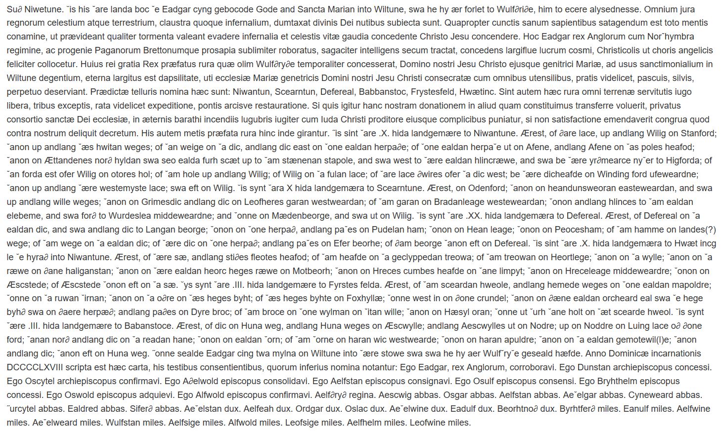
The charter of 968 containing the boundaries of Abbotstone (see below for the bounds extracted from this document) [esawyer.org.uk]
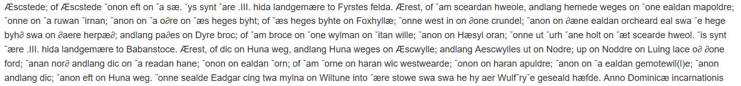
The boundaries of Abbotstone as described in the charter of 968 extracted from near the bottom of the above document [esawyer.org.uk]